Editor’s Note: This post highlights one of our announcements at Google I/O 2025. To learn how to make mobile experiences better with 3D Maps, visit our recorded session Next-gen Android experiences with photorealistic 3D Maps which will be available on May 22, 2025.
We’re committed to providing developers with transformative mapping capabilities across all platforms, and that includes immersive experiences. Last year, we unveiled photorealistic 3D Maps for JavaScript, now available in Preview, paving the way for a new era for immersive web mapping. Today, we’re expanding 3D Maps to the native mobile landscape by introducing the new Maps 3D SDKs for Android and iOS in Experimental, bringing immersive experiences across web and mobile applications.
Here’s what developers can expect from today’s launch:
-
Immersive 3D experiences now on native mobile: Photorealistic 3D Maps, currently available in the Maps JavaScript API, is now available for mobile platforms in Experimental. This brings the same rich photorealistic 3D imagery and integrated rendering capabilities to mobile app developers, including features, such as 3D camera control and map visualization capabilities like polylines, polygons, markers, and 3D models.
-
Modern mobile development for 3D Maps: The new Maps 3D SDKs are designed with modern development practices in mind with Kotlin and Swift-first SDKs. Using the latest development frameworks, developers can create native, performant user experiences for their mobile applications.
-
Multi-platform availability: Developers can now use 3D Maps across web and mobile, providing a consistent user experience regardless of platform. This simplifies development for those building cross-platform applications, enabling broader 3D access and engagement.

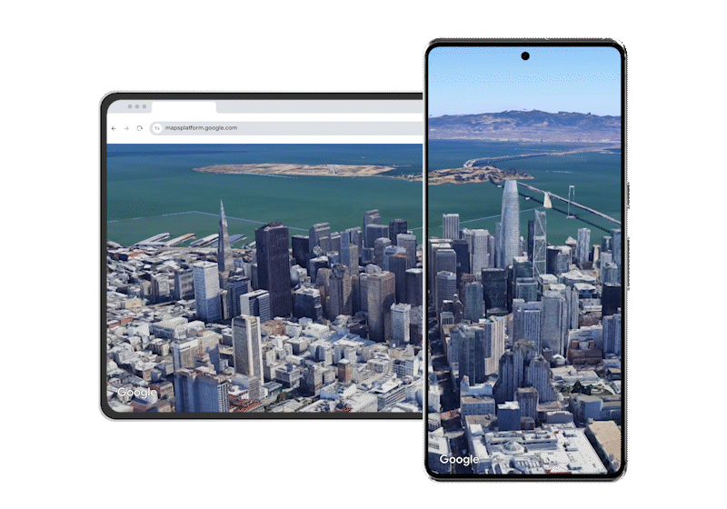
Render interactive views of Manhattan with immersive 3D Maps on web and native mobile applications
Immersive, real-world canvas for enhanced location discovery
3D Maps bring a high resolution, real-world canvas to map developers—and now mobile developers too. The Experimental release for mobile enables photorealistic views around the globe and showcases more than 2,500 cities in stunning 3D detail.
-
Dynamic 3D camera controls: Add powerful ways to navigate maps by using flexible 3D camera controls, allowing you to orient and animate the view across your chosen locations. Use preset camera paths like flyTo and flyAround for ready-to-use dynamic scene transitions and guided tours that help users understand locations from globe to block-level views.
-
Performant 3D rendering: Ensure smooth, reliable, and visually stunning experiences relying on Google’s performant rendering technology—whether you’re visualizing landmarks, planning city infrastructure, or building branded, interactive applications.
-
Tailored basemap display: Control the map’s visual emphasis ensuring the 3D map perfectly suits your application’s purpose. This means users experience a map with stunning photorealistic imagery for real world immersion, or additional information-rich content with familiar Google Maps labels and places. Like 3D Maps for web today, you can choose the Hybrid map mode with points of interest and map labeling for familiar context, or a Satellite mode for an imagery-only, focused map display.
San Francisco in 3D with dynamic camera controls and stunning visuals on web and mobile.
Built-in 3D elements for unique mobile visualization
Deliver immersive, branded map experiences with built-in 3D elements that let you seamlessly integrate your own geospatial data, providing users with meaningful real-world context. These capabilities go beyond simple visualization - making 3D maps a powerful storytelling medium, guiding users through key moments and locations. For developers, streamlined customization options and configuration tools make it easy to tailor every visual element to your brand and audience, reducing technical overhead and accelerating map development.
-
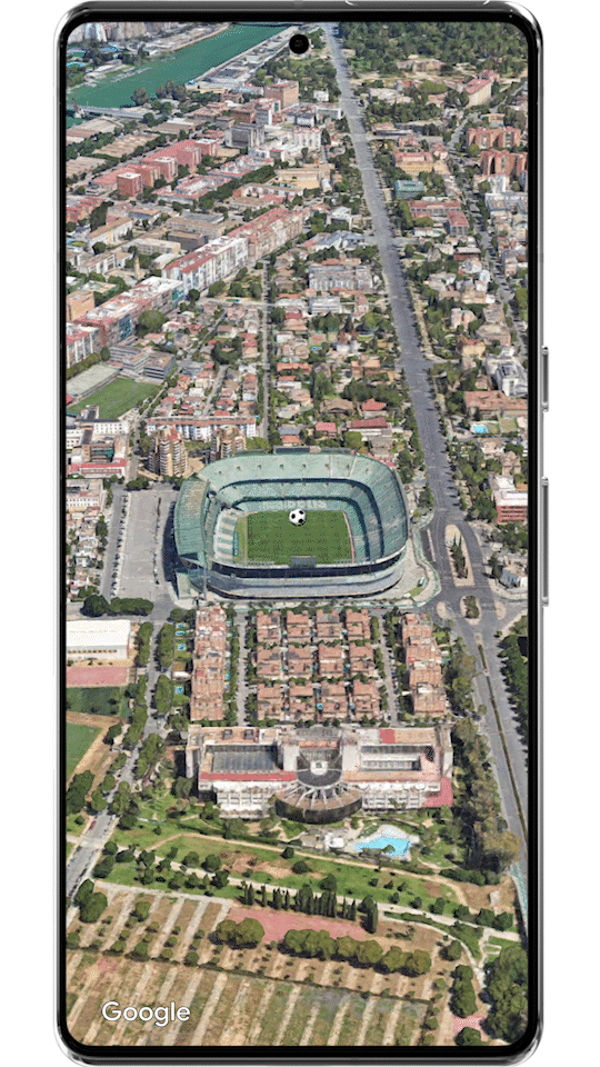
Flexible markers: Markers in 3D are highly flexible, supporting multiple altitude modes. These annotation elements enable you to pinpoint and highlight specific locations within your map, giving precise control over how each marker appears relative to real-world features-whether on a rooftop, at ground level, or elevated above the terrain.
-
Contextual overlays: Easily add context and clarity by overlaying polylines and polygons to highlight routes, buildings, or areas of interest. These customizable visuals let you emphasize specific paths or areas, making your maps not only informative but also visually distinct.
-
Custom 3D models: Render custom 3D models from a gITF asset directly in the map. This allows you to showcase unique objects—like architectural models, branded icons, or geospatial content—bringing your data to life within an authentic, real-world canvas.
Pinpoint locations with flexible 3D markers.
Bring your brand to life with custom 3D models.
Emphasize areas of interest with polygons.
Highlight routes using customizable polylines.
Explore our demo showcasing 3D Maps in action, featuring immersive views of buildings, routes, and landmarks with stunning detail and interactive elements that bring maps to life.
Seamless integration & modern mobile development
Getting started with 3D Maps on mobile is incredibly simple, especially if you’re already familiar with our existing Maps SDKs. Simply enable the Maps 3D SDK for Android and Maps 3D SDK for iOS in the Cloud console to start using 3D Maps. With an API key and a few lines of code, you can easily display a 3D map view in your application.
Built with modern development in mind, the Maps 3D SDK for Android is Kotlin-first and automatically delivers new features through Google Play Services—no app republishing needed for updates. The Maps 3D SDK for iOS is Swift-first, allowing developers to create modern, declarative UIs using SwiftUI with simple syntax for a more productive development experience.
Try these code samples to get started. Each Koltin and SwiftUI sample shows a 3D map looking at the Empire State Building, specified using altitude, range, tilt, and heading.
Kotlin
class HelloMapActivity : Activity(), OnMap3DViewReadyCallback {
    private lateinit var map3DView: Map3DView

    override fun onCreate(savedInstanceState: Bundle?) {
        super.onCreate(savedInstanceState)
        WindowCompat.setDecorFitsSystemWindows(window, false)
        setContentView(R.layout.activity_hello_map)

        map3DView = findViewById(R.id.map3dView)
        map3DView.onCreate(savedInstanceState)
        map3DView.getMap3DViewAsync(this)
    }

    override fun onMap3DViewReady(googleMap3D: GoogleMap3D) {
       googleMap3D.setCamera(
            camera {
                center = latLngAltitude {
                    latitude = 40.748339
                    longitude = -73.985912
                    altitude = 211.1
                }
                heading = 52.0
                tilt = 68.0
                range = 1039.0
            }
        )
        googleMap3D.setMapMode(Map3DMode.SATELLITE)
    }
}
SwiftUI
import SwiftUI
import GoogleMaps3D

struct Hello3DMapDemo: View {
  //initialize a camera looking at Manhattan
  @State private var camera: Camera =  .init(
    latitude: 40.748339, longitude: -73.985912, altitude: 211.1,
      heading: 52,
      tilt: 68,
      range: 1039
    )

  var body: some View {
    VStack(spacing: 0){
      //basic Map initialization
      Map(camera: $camera, mode: .satellite)
    }
  }
}
Try 3D Maps on mobile, share your feedback
This is our first mobile 3D Maps release, making it an exciting time to explore immersive map experiences on Android and iOS. To learn more, check out our Google I/O technical session, Next-gen Android experiences with Photorealistic 3D Maps for a deep dive into the capabilities and features.
You can get started quickly with sample code and codelabs in the Maps 3D SDK documentation for Android and iOS. Share your feedback and feature requests through the public issue tracker for Android and iOS.
We hope you start experimenting with 3D Maps for mobile today—we’re excited to see what you create. And, to share what you build, visit our Google Maps Platform Discord community.
